Executive Summary
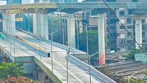
The Mira-Bhayander flyover represents a significant infrastructure development in Mumbai's metropolitan region, designed to address chronic traffic congestion along the Mira Bhayandar Road corridor. Constructed by the Mumbai Metropolitan Region Development Authority (MMRDA) as an integral component of Metro Line 9, this double-decker structure has become the subject of intense public scrutiny following viral videos highlighting its unconventional lane configuration.
Project Overview
Background and Context
The Mira-Bhayander region, located in the northern suburbs of Mumbai, has experienced rapid urbanization and population growth over the past decade. The Mira Bhayandar Road serves as a critical arterial route connecting these suburbs to Mumbai's central business districts. However, the road has long suffered from severe traffic congestion, particularly at key junctions such as Golden Nest Circle and Railway Phatak Road.
The flyover project was conceived as part of MMRDA's broader strategy to integrate road and metro infrastructure, providing a comprehensive solution to the region's transportation challenges. The structure supports Metro Line 9 on its upper deck while facilitating road traffic on the lower deck, exemplifying modern multi-modal urban planning.
Design and Engineering
Structural Configuration
The flyover features a sophisticated design that adapts to varying spatial constraints along its 1.5-km alignment. The structure can be divided into two distinct segments:
Segment 1: Approach to Golden Nest Circle
From the starting point at Deepak Hospital to Golden Nest Circle, the flyover maintains a 2+2 lane configuration (two lanes in each direction). This four-lane design includes:
- Slip roads on both sides for traffic dispersal
- Integration with the five-road junction at Golden Nest Circle
- Adequate width to handle high-volume vehicular movement
- Structural support for the elevated Metro Line 9 above
Segment 2: Golden Nest Circle to Railway Phatak Road
Beyond Golden Nest Circle toward Bhayandar East, the flyover transitions to a 1+1 lane design (one lane up, one lane down) along the median. This configuration is a direct response to right-of-way constraints specified in the Development Plan for the area.
Design Rationale
The lane transition has been the primary source of controversy, but MMRDA has provided detailed technical justification for this design choice:
1. Right-of-Way Constraints
The available road width beyond Golden Nest Circle is significantly narrower than the approach section. According to the municipal Development Plan, the permissible construction zone is limited, preventing a continuous four-lane configuration.
2. Phased Development Strategy
The current two-lane configuration represents Phase 1 of a planned expansion. MMRDA has incorporated provisions for future widening, with space reserved for an additional 1+1 lane on each carriageway. This expansion is contingent upon:
- Coordination with Mira-Bhayandar Municipal Corporation (MBMC)
- Acquisition of additional land parcels
- Extension across the Western Railway line to Bhayandar West
- Regulatory approvals for expansion
3. Traffic Distribution Logic
The Golden Nest Circle serves as a major traffic distribution node. MMRDA's traffic studies indicated that a significant proportion of vehicles disperse at this junction via slip roads and connecting routes, reducing the volume requiring continuation on the flyover toward Railway Phatak Road.
Safety Features and Measures
Built-in Safety Infrastructure
MMRDA has incorporated multiple safety features into the flyover design to mitigate risks associated with the lane transition:
- Rumble Strips: Installed before the lane transition to alert drivers of changing road conditions
- Crash Barriers: Anti-crash barriers positioned along critical sections to prevent vehicular accidents
- Delineators: Retro-reflective delineators marking lane boundaries and transition zones
- Signage System: Comprehensive directional boards and warning signs indicating lane reduction ahead
- Retro-reflective Tags: Enhanced visibility during night-time and low-visibility conditions
- Road Markings: Clear thermoplastic markings guiding traffic through the transition
Post-Controversy Safety Review
Following the viral video incident in late January 2026, MMRDA conducted an emergency safety audit on January 29, 2026. Recommendations from the safety review include:
- Installation of kerb stones in place of traditional road medians to better demarcate lanes
- Additional traffic calming measures before the transition zone
- Enhanced lighting at the narrowing section
- Deployment of variable message signs (VMS) for real-time traffic guidance
- Speed reduction measures including speed breakers or speed limit enforcement
The Controversy: Public Perception vs. Engineering Reality
Origin of the Viral Video
In late January 2026, a video showing the lane transition from four lanes to two began circulating on social media platforms including Instagram, Facebook, Reddit, and Twitter. The video was accompanied by critical commentary describing the flyover as:
- A "bottleneck" creating traffic congestion
- An "engineering marvel" (used sarcastically)
- A "death trap" posing safety risks
- Evidence of poor planning and design flaws
The video garnered millions of views and sparked widespread debate about infrastructure quality in Mumbai's expanding metropolitan region.
MMRDA's Response
On January 27, 2026, MMRDA issued official clarifications addressing the public concerns. MMRDA characterized the viral narrative as "misleading" and emphasized that the project followed all regulatory guidelines and engineering standards.
Challenges and Concerns
Despite MMRDA's justifications, several legitimate concerns merit attention:
Traffic Bottleneck Risk
The reduction from four lanes to two creates a potential bottleneck, particularly during peak hours. If traffic volumes exceed the capacity of the two-lane section, congestion could build up, negating some of the flyover's intended benefits.
Driver Behavior and Adaptation
Indian road users often struggle with lane discipline and sudden changes in road configuration. The transition zone requires heightened driver awareness and compliance with traffic rules, which may not be consistently maintained without strict enforcement.
Phase 2 Implementation Uncertainty
The effectiveness of the current design depends heavily on timely implementation of Phase 2 expansion. Delays in land acquisition, regulatory approvals, or funding could result in the two-lane configuration persisting longer than planned, exacerbating congestion issues.
Recommendations
Short-term (Pre-inauguration)
- Implement all safety review recommendations before full opening
- Deploy traffic police personnel at the transition zone during initial weeks
- Install variable message signs (VMS) providing real-time traffic guidance
- Conduct public awareness campaigns explaining the flyover design and usage
- Establish a monitoring system to track traffic flow and incident rates
Medium-term (First Year of Operation)
- Conduct quarterly safety audits and traffic impact assessments
- Gather data on bottleneck formation and adjust signal timings accordingly
- Enforce strict lane discipline and speed limits through automated systems
- Maintain continuous dialogue with local communities and address concerns
- Initiate preliminary work for Phase 2 expansion
Long-term (Strategic)
- Accelerate Phase 2 land acquisition and regulatory approvals
- Explore alternative routes or supplementary infrastructure to distribute traffic
- Integrate the flyover into broader metropolitan transportation planning
- Document lessons learned for application to future projects
- Establish transparent communication protocols for controversial infrastructure projects
Conclusion
The Mira-Bhayander flyover represents both the potential and challenges of urban infrastructure development in rapidly growing Indian cities. While the project addresses genuine transportation needs through innovative double-decker design and metro integration, its controversial lane transition highlights the complexities of building within constrained urban environments.
MMRDA's technical justifications for the design are grounded in real constraints related to land availability and regulatory frameworks. The phased development approach, though pragmatic, places significant responsibility on authorities to ensure timely expansion and maintain public confidence through transparent communication.
Ultimately, the project's success will be measured not by initial public perception, but by its long-term performance in safely and efficiently moving traffic while integrating seamlessly with Metro Line 9. Continuous monitoring, adaptive management, and genuine responsiveness to user experience will determine whether this infrastructure investment delivers the promised benefits to Mumbai's northern suburbs.